Sat July 25th Open 11 AM–5 PM
Essays
Where shall we go from here?
The 2019-2020 YBCA Public Participation Fellow cohort was originally gathered to collaborate and build on communities-based projects that demonstrated the mobilizing of public participation. However, as the Fellows worked on bringing their work to fruition, the world was hit with COVID-19. The cohort were then challenged to grapple with the question: what is public participation now?
For If A Tree Falls, a project curated by YBCA Public Participation Fellow Lian Ladia, artist Weston Teruya was invited to respond to how he introspects during this pandemic moment. As an artist unable to create physical work, he wrote, “Where Do We Go From Here,” a thoughtful response to issues he has been grappling with as a sculptor. In this pandemic, how does one think about artistic production in the material sense? Instead of producing new work, Teruya reflects on his process through writing and returns to the core of his artistic research. His writing, along with collaborators FOBcast and Plants Have Feelings, contributes to If A Tree Falls as a marker of how artists are reflecting on their work in the face of a crisis.
A little over a year ago, I was invited by artist and University of Hawai‘i, Mānoa Professor Gaye Chan to return to Honolulu, my hometown, to create a project reflecting on the visual language and politics of development in Kaka‘ako, a neighborhood on the island of O‘ahu’s south shore. Gaye felt this would be an opportunity to apply my interest in how power and struggles for equity manifest in the built environment and everyday visual culture to a place where I have ties but never had an opportunity to create a project. This essay is a reflection on the underlying questions that fueled my project and what it meant for me to re-examine the place where I grew up.
As I dove into researching the site and its history, my inquiries became entangled with more personal questions around memory and what it meant to speak about a place that is my hometown, but not my homeland. Nearly all of my family lives in Honolulu, but I’ve lived away from the islands longer than I spent there growing up. It’s a place I visit almost every year and have seen transform in a rapid slideshow of slippery memories over decades. I still feel the pull back at the end of a long tether, even if every time I return I view it through eyes more akin to a tourist’s.
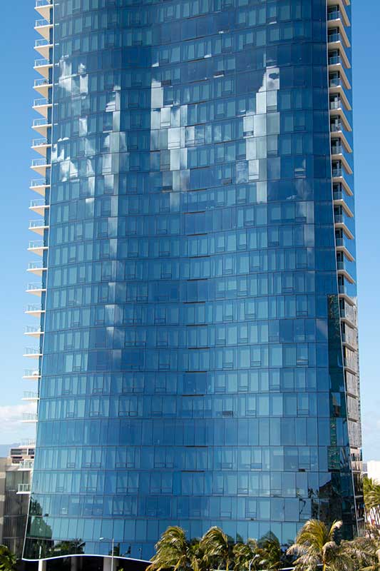
The facade of the Waiea in Ward Village (2019), photo by the author.
This simultaneity of distance and intimacy led me to focus on the Ward Village development in the Kaka‘ako neighborhood, a rapidly developing place shaped by local interests and the visions of people outside the islands. The Howard Hughes Corporation, a Texas-based developer, counts Ward as one of its national portfolio of planned neighborhoods. Parallel to the luxury emphasis of its high-rise condo housing, Ward is designed as a heavily trafficked district driving local nightlife and commercial activity as the location of one of the largest remaining movie theater complexes and its adjacency to the island’s retail center. Perhaps unsurprising to those familiar with the relationship between contemporary art and developer investments, Ward’s charitable arm and the Hughes Corporation were primary sponsors of the first two Honolulu Biennials (now a Triennial) while empty retail space in the complex was home base for the sprawling exhibition series. Art from the Biennial serves as the marketing imagery on the Howard Hughes website, its cultured flash more useful than the references to Native natural beauty driving the Ward Village brand. Contemporary art appeals to distant buyers looking to invest in a place of sophisticated modernity rather than just the temporary tropical getaway they imagine Hawai‘i to be. I also want to acknowledge that whatever critiques I may have, it is not a simple binary. I’ve visited both Biennials and love the possibilities they hold for centering contemporary visual art exchanges and discourses rooted in the Pacific, especially through thoughtful curation, such as 2019’s predominantly Pacific Islander and indigenous artist line up. Like anything dealing with the politics of home, my feelings are complicated and I find myself implicated in these investigations.
Because of its social, commercial, and artistic role, Ward is an unavoidable place in my familial and professional lives whenever I return home. In that way, it reminds me so much of the SoMa and other communities I’ve worked in where art and commerce intersect with accelerating unaffordability and the displacement of people who created a place’s identity. Looking at Ward has been helpful in understanding a part of home (and memory) that I was only partially informed of, and the process of unpacking the layers of this site resonates with so much of the rest of my practice. When I think about Lian’s thematic prompt of “If a tree falls…,” I’m reminded of the responsibility to seek out a deeper understanding of what happens under the surfaces of the places that seem so familiar that I take for granted–like the hometown I casually return to, visiting my family without always acknowledging and investigating its continuing complications, or the sounds of falling trees I did not previously attune myself to hear.
The following are excerpts from the research I conducted before and after my project in Honolulu last year, focusing on four moments: three documented in photographs and a fourth retold through oral histories.
.Surfaces.
The first two photos are a dramatic contrast. One, which I took while walking around the expanding Ward development in early 2019, captures the sleek glass surface of the Waiea, the complex’s flagship high-rise condo. The mirror tinted façade reflects clouds in the seductively blue sky, broken up and gridded by window frame edges. This side of the building has the gradual arcs of a wave out on the deep ocean, its unseen energy rumbling beneath. Standing before the giant mass, it’s clear that the tower’s sleek architecture aims for luxury and an organic sheen, glass capturing a cloak of sky to soften the ostentatiousness of a tower on the Kaka’ako waterfront.
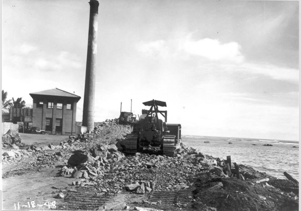
Archival photo of Kewalo Incinerator No 1 (1948), via Peter T. Young
As I investigated, I often turned to the Howard Hughes Corporation and Ward Village marketing site to get a sense of how they framed the project. They describe the village’s location as being “between the Pacific Ocean and the Koʻolau Mountains,” (a note that would vaguely apply to half the island) and deliberately situate the tower along the mountain to the ocean water cycle (evaporation – condensation – rainfall – watershed – stream – ocean). Pre-colonial kānaka ‘oiwi (Native Hawaiian) society organized the islands through a series of political and geological divisions called ahapua‘a—slivers of land typically running from the mountain to the ocean—recognizing the interlinked ecosystems that cascade along the waterways on an island and the need to organize community structures along its backbone. Ward’s promotional invocation attempts, like the glass façade’s reflected sky, to naturalize the luxury complex as part of the geological and cultural landscape.
The second photograph is a 1948 black and white image. What appears to be a bulldozer sits on a small mound of broken rock next to the ocean, a modest industrial building in the background with a tall, imposing concrete smokestack cutting through the sky beside it. According to the photo’s provenance, it depicts the Kewalo Basin incinerator, the facility where a then-growing Honolulu’s trash was gathered and burned just a few blocks oceanside from where the Waiea stands today. The city and developers sought to transform the Southern shoreline—Waikīkī to Kaka‘ako—from agricultural marshlands that hosted lo’i kalo (taro patches), ponds for pa‘akai (salt) harvesting, loko i‘a (fishponds), and later rice paddies tended to by Japanese settlers, into paved, pruned, and globally marketable waterfront real estate. While this move was politically justified as a public health need—they reframed wetlands as incubators for mosquito-borne disease—unspoken in that narrative was the role colonialism played in fracturing waterways and stagnating once thriving ecosystems. Developers—the kind whose names now anoint streets and civic complexes—reshaped the land by injecting fill made up of broken coral and charred waste from the incinerator into the marsh and dredged reefs.1 This incinerator eventually fell into disuse and after several decades, the grounds were capped, planted over, and reopened as Kaka‘ako Waterfront Park in 1992.
Today, the park’s most notable feature is its steep, grassy hills, with only curved venting pipes at the top of some of the mounds as evidence of what waste remains below idyllic views of the ocean and Kewalo Basin Harbor. I distinctly remember my family among the many who flocked to the park for picnics when it opened. The hills were popular runways for ice-block and cardboard sledding for the bold who didn’t mind the possibility of wiping out on the concrete walking paths snaking around the foot of the steep drops. (I was never that brave.) In gathering materials for the sculptural facet of my project, I still found assorted pieces of cardboard around the edges of the park left behind for others to use, grass and mud streaks on their surface. I recall being told the area was a former dump, but this was mostly a background curiosity for which I had no additional context. The expanse of green next to the ocean reads as a natural surface in the landscape; a populist civic asset, remediated and accessible.
Despite attempts to cloak the built environment in the pristine visuality of the natural world, the original waterways and marshlands, filled and layered with concrete, continue to creep in at the edges. The area has a persistent penchant for floods that no amount of industrialization has fully erased. With climate change’s threat of rising sea tides, projections from University of Hawai‘i ecological researchers indicate the fill areas will be at least partially reclaimed by the ocean, possibly leaving these luxury landscapes underwater at some point in the future. 2
.Time.
Let’s talk about the unphotographed oral history. It’s a tale about the sticky persistence of structural violences injected into a place, haunting it in endless returns. It’s also the fallen tree amidst these photos, underrecognized but important in understanding what has happened here. In the 1920s, the area roughly between the current Kaka’ako Park and Ward Village was colloquially known as Squattersville, a settlement of small makeshift homes built and occupied by about 700 kānaka ‘oiwi folks who reclaimed this sliver of colonial government-owned property. Residents organized to advocate for infrastructural resources like plumbing and roads, but demands were never met. Unsurprisingly, journalistic coverage of the community is near non-existent, though a newspaper editorial from the time expressed bewilderment at the audacious possibility of people occupying publically-owned property and predicted that when they were displaced, there would be “cries of injustice and oppression” in response to pushing Native folks out of their homes. 3In a neoliberal sleight of hand (perhaps sparked by a vision of the distant future), Mayor Wallace Farrington proposed the area be razed and a park be built on the location in order to “give everyone equal access to the area, not just those who got there first.”4
A billboard on the side of the A‘eo in Ward Village (2019), photo by the author.
Not long after, Squattersville resident Mary Kauhana Naito remembers the community’s homes being unceremoniously bulldozed in a major sweep. Prior to the neighborhood razing, residents erected a large sign reading “Where shall we go from here?,” pleading for justice, crying for people to hear them. Naito’s family and some others tried to hold onto their space, even after their homes had been flattened, but they eventually moved out of the area and further inland since there was no shelter from the elements left in the rubble.5
In recent years, houseless island residents have occasionally reclaimed Kakaʻako park, itself built on the distant shadow of Squattersville, creating makeshift tent communities and tapping into the park’s electrical infrastructure and plumbing. In turn, the city conducts intermittent draconian sweeps of the park—often scheduled during the holidays when public attention is divided—evicting people and demolishing their makeshift homes. The spectres of state violence and lost homes and stories—particularly in an area with one of the highest costs of living in the country—are ever present. In an inversion of Farrington’s perverse appeal to the public, the state has closed the park for months at a time, attempting to completely close access to the area to thwart potential squatters.
The final photo, also taken while walking through Ward in early 2019, shows a two-paned, wall-mounted billboard above a row of bike-share ports along the sidewalk. The enlarged black and white photograph documents a lo‘i kalo from the area prior to industrialization, simultaneously gesturing to the history and kānaka ‘oiwi cultural roots of the land while fixing it with a faded, grainy lens. The billboard is mounted on the backside of the A‘eo, another luxury development in the Ward complex, this one featuring a ground floor Whole Foods. At its center (behind the tree in this photo), the billboard features an inset inviting passersby to “Dine. Drink. Discover.,” a pitch for the neighborhood’s transformation into a new, local frontier, clean and future-oriented, taking only the elements of history and culture in support of the brand.
The marketing copy and aspirational design of the Ward luxury towers gesture towards a shining future. Glassy surfaces attempt to absorb and blend themselves into the landscape even as they pile tons of metal and concrete upon the echoes of broken coral, debris, disrupted waterways, razed homes, and kānaka ‘oiwi agriculture. The entire enterprise curls back in on itself, haunted by the wounds of colonial violences to Native people and the land. The developers are 21st century savvy: they work with cultural consultants, select a calculated garden of Native plants for landscaping, and share poetic narratives that describe building names in ‘ōlelo Hawai‘i (Hawaiian language). By carefully recounting their steps on marketing website blogs, they channel these spectres into choreographed gestures. Perhaps tellingly, none of these marketing stories (or the photographic archive) discuss modern struggles for housing like Squattersville. The land continues to be haunted by the phantoms of colonialism, ecological fracturing, and inaccessible housing. But as we look to the future, where would we go if, instead we listened back in time to the fallen trees and re-centered the question posed by Squattersville residents: Where shall we go from here?
- Young, Peter T. “Kakaʻako Land Fill.” Ho‘okuleana, March 7, 2014, http://totakeresponsibility.blogspot.com/2014/03/kakaako-land-fill.html
- Their Hawai‘i sea level rise viewer can be accessed here: http://www.pacioos.hawaii.edu/shoreline/slr-hawaii/
- “Squattersville.” Honolulu Star-Bulletin, 4 June 1924, p. 1.
- “Governor Has Park Plan For Kewalo Area.” Honolulu Star-Bulletin, 5 June 1924, p. 22.
- Nakayama, Perry. “Oral History Interview with Mary Naito,” Remembering Kakaako: 1910 – 1950, transcript of tape number 3-19-1-77, University of Hawai‘i, 1977, https://scholarspace.manoa.hawaii.edu/handle/10125/30165. October 25, 1977, Waimanalo, O‘ahu. Additional background from Clark, John R.K. “Hawai’i Place Names: Shores, Beaches, and Surf Sites.” University of University of Hawai‘i Press, 2002. And critical contextual framing for this section informed by Adele Balderston’s creative walking tour project, 88 Block Walks. “Walk #5: The Living Archive.” 88 Block Walks. 2014.